It was a little after 1 p.m. on Tuesday when she felt the ground start to shake.
“I’ve never felt something of this sort,” Gisela Pérez de Acha told Poynter. “I’ve lived in Mexico all my life — we are quite used to earthquakes. Everything was shaking to the point where I got dizzy and we could barely get out (of the building).”
Pérez de Acha was at the headquarters of Horizontal, a digital news organization, near central Mexico City when the earthquake hit. She knew it was serious when she saw construction workers fall off the building across the street.
“We were just super scared because the building right in front of us was shaking a lot,” said Pérez de Acha, who works for both Horizontal and Derechos Digitales, a human rights nonprofit. “We all knew something was terribly off.”
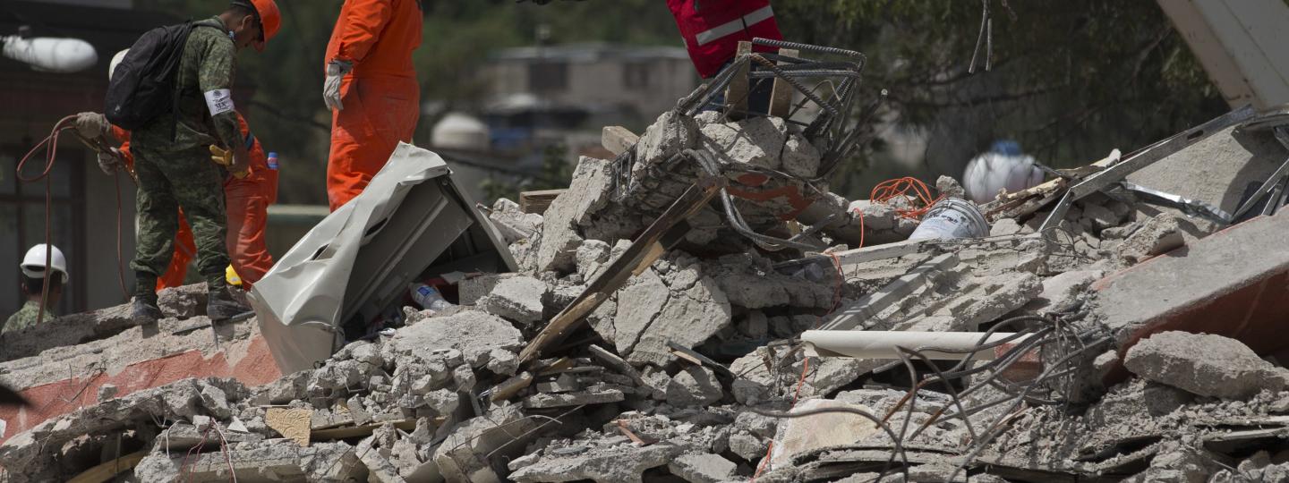
At least 225 people have died in Tuesday’s 7.1-magnitude earthquake, which hit exactly 32 years after an infamous quake that killed about 9,500 people and hours after an evacuation drill to commemorate the anniversary. As the second earthquake to rock Mexico in the past month — arriving on the heels of a powerful 8.1-magnitude earthquake that struck the southern coast Sept. 7 — it didn’t take long for panic to blanket the capital.
“People were just yelling on the streets. There was a very strong stench of gas; there were a lot of gas leaks,” Pérez de Acha said. “We were just trying to figure out where to go, what to do.”
After calling family and friends and checking on property, Horizontal journalists jumped into action. On Wednesday, they gathered at the office to brainstorm ideas, and it quickly became apparent that people needed supplies, shelter and medical attention as quickly as possible. Going off a custom Google Map created by Sergio Beltran, a Mexico City architect, that showed which buildings had toppled in the quake, they started to think about how they could create a map that would show people which locations still had resources and which reports were hoaxes.
Their solution: crowdsourcing.
“What we are doing right now is two things: describe all the social media conversations about what is going on around the earthquake, like several damaged buildings and evacuations, but also what are the needs of the shelters … (and) gather things for the people. We’re validating that information with a network of activists,” Antonio Martínez Velázquez, co-founder and editor of Horizontal, told Poynter minutes before he evacuated Horizontal’s building because of a gas leak. The organization is now being housed temporarily by Vice Mexico, said Pérez de Acha, who was in charge of coordinating donation efforts and organizing volunteers.
The project, called Verificado 19S, relies on 250 volunteers submitting updates from around Mexico City. Those people come from seven organizations partnering with Horizontal, including Bicitekas, Data Cívica and Democracia Deliberada, as well as citizens who want to help. The volunteers fill out Google Forms to report landslides, gas leaks, structural damage, availability in shelters and where to find and donate resources like food and water.
In a way, that strategy turns traditional journalism on its head.
“I think that is the main innovation in this — the fact-checking thing,” Velázquez said. “Journalists are such centralized people because we want to verify every piece of information, but since we designed this form with a lot of needs that people can fill, we played the trust and confidence card (with our audience).”
Essentially, Verificado 19S is using user-generated content to fact-check word of mouth reports about the situation in the city. Think Gasbuddy, but for earthquake recovery rather than hurricane preparedness.
In addition to the form, Horizontal has set up a call center to receive tips about damage around the city.
By coupling those tips with updates from the field, the news organization had collected more than 25,000 data points as of Friday evening and created an interactive, real-time map showing where people can get help in four of the affected states.
“We worked with coders to build a map with four different categories and four different links,” Pérez de Acha said, “with the sole purpose of verifying information and combating fake news during a very catastrophic time, when a lot of people want to help but they didn’t know where to go."
One of those coders is Miguel Escalante, a data scientist at Cultura Colectiva, a Mexico City-based digital news platform. He said each time a volunteer submits a response in the Google Form with an update from the field, it’s recorded in a Google Sheet, which is then translated onto the main Google Map. While simple, the entire system has to be maintained by hand since Google’s back-end is highly centralized; instead of manipulating the source code to push data entries to the map, Escalante has to move the information over by hand.
The work has already received significant attention. On Wednesday, NASA’s Jet Propulsion Laboratory cited the crowdsourced map as a tool it used to conduct preliminary verification work following the earthquake.
And — of course — there’s the question of misinformation.
Small hoaxes spread quickly after the earthquake, such as one that was shared on WhatsApp claiming a bridge was about to fall when it wasn’t, Pérez de Acha said. But one of the biggest false stories originated on Televisa and circulated on other major television networks on Wednesday following the collapse of a school in the city. Several outlets reported a 12-year-old girl named Frida Sofia was rescued after being buried in the rubble of the Enrique Rebsamen school. But the story, which trended on Twitter under #FridaSofia, fell apart when government officials were unable to verify the girl’s identity or locate her parents.
“There was a lot of collective paranoia figuring out who the little girl was,” Pérez de Acha said.
Now it’s possible the girl never existed.
The ability of Horizontal, its partner organizations and volunteers to relay what information is factual depends on Mexicans’ access to cell and internet service. At first, Pérez de Acha said it was hard to spread accurate information to the most affected zones of Mexico City. But while one might question the availability of cell service and data networks in the aftermath of the earthquake, Pérez de Acha said most people in the city center have power and access to the internet, enabling them to view the interactive map. Major phone companies also waived service fees earlier in the week to alleviate earthquake victims, Pérez de Acha said.
The result: a hugely popular service. Four days into the project, the map has amassed more than 4.5 million page views.
“We actually didn’t have any other reference. This kind of started with the Google mapping and saw a need for the verification of information,” Pérez de Acha said. “Of course, a map will never reflect enough information — especially it’s never going to be real-time information.”
But it’s a start.